Aerial beach photography is drone-captured imagery of the coastline, shot at altitude, and in Ireland it produces results that most people do not expect until they see them for the first time.
The assumption is that the best coastal aerials come from warm climates. Clear water, saturated colour, obvious drama. Ireland disproves that within the first frame.
The light here does things to sand and sea that the Mediterranean simply does not have the weather to produce. What makes Ireland specifically one of the most remarkable coastlines to shoot from the air, and what you need to know before commissioning a shoot, is what this guide covers.

Why Irish Beaches Photograph So Differently From the Air
Most people assume the best aerial beach photography happens in warmer climates. California, Australia, Italy, the Mediterranean. Busy summer beaches, vibrant colours, swimmers and beach umbrellas creating a dense visual texture below.
Ireland does something different.
The Wild Atlantic Way coastline is not a postcard. It is dramatic, raw, and full of contradiction. It is also Ireland’s most visited tourism brand region, drawing 2.3 million overseas visitors in 2024 and generating €2.37 billion in revenue.
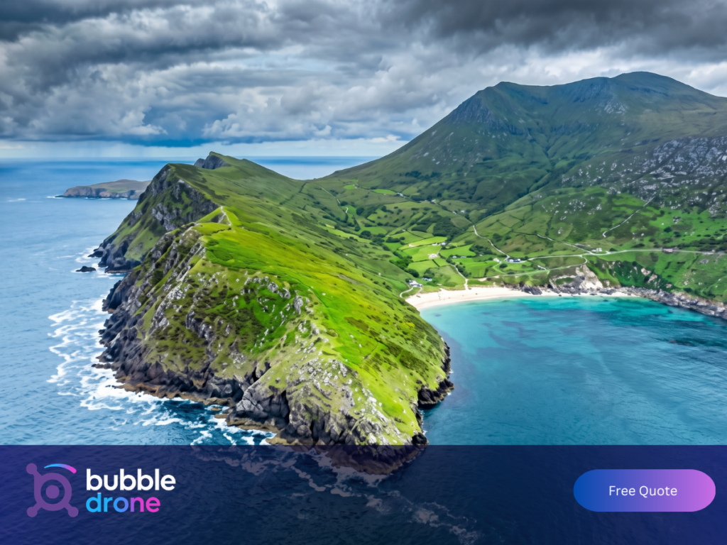
Coastal hospitality businesses along that route are operating in a high-value, highly competitive market where visuals do serious commercial work. A beach in Donegal or Sligo can shift from a deep golden strand to dark rock face within metres. The Atlantic light at dawn or dusk does things to sand and sea that no filter replicates. The colour of the water along the west coast, particularly over white shell sand, produces that impossible turquoise you see in photos and assume has been edited.
From an aerial angle, all of this becomes a visual language of its own. The cliff faces of Sligo read as abstract vertical geometry. The tidal flats in Wexford reveal patterns that only exist at a certain hour. The long curve of a beach in Kerry, seen from 120 metres, gives you the full shape of the bay in a single frame.
What Makes a Strong Aerial Beach Photograph
The difference between a competent aerial beach photo and a genuinely great one comes down to three things: timing, composition, and pilot experience. If you want to understand how those same principles apply beyond the coastline, our guide to drone photography in Ireland covers the full picture.
Timing is non-negotiable. The best aerial beach shots happen in the first hour after sunrise or the last hour before sunset. The low angle of light creates shadow and texture that midday shooting eliminates. Sand that looks flat and featureless at noon becomes a landscape of ridges, ripple marks, and gradient at golden hour. Water that is opaque grey under cloud becomes translucent green when the sun is low and the angle is right.
The edge of a receding tide leaves tidal patterns in wet sand that look, from above, like brushwork. A beach shot at high tide gives you a clean sand-to-sea line. A beach shot at low tide gives you a kilometre of texture. Both are useful, but they are completely different images.
Composition at altitude requires thinking in shapes rather than subjects. The eye reads aerial beach photography the way it reads abstract art. A line of rocks cutting across white sand. The curve of a wave about to break. A single figure walking a long empty beach, included in the frame to give scale to everything around them. Every element in the frame was put there on purpose.
Pilot experience is what brings the first two together reliably. Knowing where to position for the sun, reading wind at altitude versus ground level, understanding how fast an Irish coastal weather window can close: all of it comes from time on site. Certification confirms training. It does not confirm eye.
Where the Best Aerial Beach Photography Happens in Ireland
Ireland has over 2,500 kilometres of coastline. Not all of it produces great aerial beach photography, and the locations that do are not always the most famous ones.
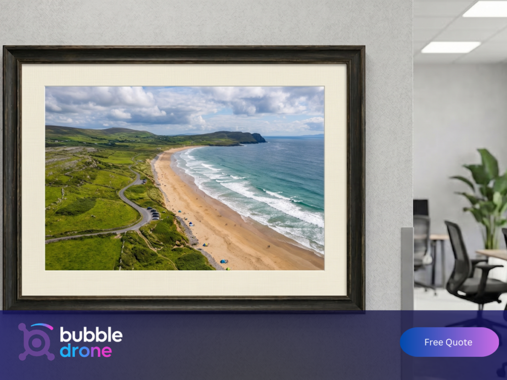
Brittas Bay, County Wicklow is one of the most accessible beaches from Dublin and photographs exceptionally well from the air. The dune system behind the beach creates a layered landscape, and the gradual depth of the water produces visible colour gradation from shallow to deep.
Inchydoney, County Cork has been voted Ireland’s best beach multiple times and holds a Blue Flag designation. It also has a natural split beach formation that is only really legible from altitude. The view across both strands from above, with the headland between them and the Atlantic beyond, is one of those coastal shots that earns its place on a wall.
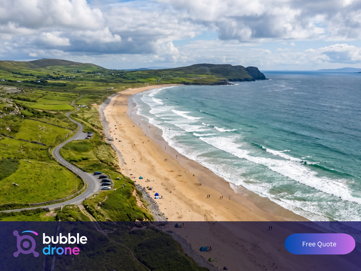
Rossnowlagh, County Donegal is a long south-facing surf beach that catches late afternoon light across a wide arc. From altitude, with dunes on one side and open Atlantic on the other, it gives you that particular sense of scale that makes an aerial beach photograph feel genuinely large rather than just high.
Curracloe, County Wexford is the beach most aerial photographers underestimate until they fly it. Wide, straight, backed by tall dunes, with a geometry that reads as almost architectural from above. It was used as a D-Day landing location in Saving Private Ryan, which tells you something about how it photographs under difficult light. An overcast day that would ruin most beach shoots actually works in Curracloe’s favour. The flat light removes shadow contrast and lets the sand texture carry the frame in a way that a bright sunny day physically cannot.
Bundoran, County Donegal produces a completely different style of aerial beach photography: active, structured, and people-centred. As a surf town, the beach below has visual energy. A drone at the right angle on a busy surf day captures the sea as a series of breaking wave lines, each one carrying a different group of surfers, with the town behind and the headland framing the whole scene. It is the closest thing to a California-style aerial beach shot you will find in Ireland.
Who Commissions Aerial Beach Photography in Ireland
Tourism and hospitality businesses are the most consistent commissioners of coastal drone content in Ireland. Hotels, holiday parks, surf schools, and glamping sites near the coast all need aerial images that show their location in context.
Ground-level photography shows the sand. Aerial photography shows the sand, the full setting, the surrounding landscape, and the proximity of the business to all of it. That context is the difference between a location and a destination.
The commercial case is direct. Properties with professional photography earn on average 40% more revenue than those without it. For a coastal hotel, a single aerial shoot typically pays for itself within the first day of additional bookings it generates. The content runs for twelve to eighteen months across websites, social media, and campaign materials. The cost per use is lower than a stock library subscription, and the content is specific to their location.
Wedding couples with coastal ceremonies are a growing segment, and for good reason. Ireland’s coastal venues, from cliff-top locations in Clare to beach ceremonies in Donegal, are settings where the scale of the location is half the point. A drone above a beach ceremony captures that scale and the intimacy of the moment simultaneously. No ground-level photo can do both at once.
Coastal property developers and high-value residential marketers use aerial beach photography to establish location in a way that site visits and brochures cannot. A planning submission or sales campaign for a property near the shoreline needs images that show the relationship between the site and the sea. That relationship is only visible from altitude.
Film projects, brand campaigns, and tourism promotional content make up the fourth stream of commissions. This work regularly requires cinematic coastal footage alongside still imagery, sometimes incorporating FPV drone work for fast, low-altitude coastal sequences that put the viewer inside the landscape rather than above it.
Can You Fly a Drone Commercially on Irish Beaches?
Commercial drone operations on Irish beaches require authorisation from the Irish Aviation Authority (IAA) under EASA regulations. Flying commercially without the correct licence is illegal. Additional restrictions apply near Natura 2000 protected coastal habitats and controlled airspace around Dublin and Cork airports. A licensed operator knows these restrictions before arriving on site.
This is the section most guides skip, and it is the most practically important one for anyone commissioning a beach drone shoot in Ireland.
The Irish Aviation Authority (IAA) regulates all commercial drone operations in Ireland. Pilots conducting commercial aerial photography are required to hold the appropriate IAA authorisation, in compliance with EASA regulations. This is not optional, and it is not a formality. An unregistered pilot operating commercially on a public beach is doing so illegally, and the liability implications for the business that commissions that work are real.
Beyond general IAA licensing, some coastal areas carry specific restrictions. Natura 2000 sites, which cover a significant portion of Ireland’s protected coastal habitats, require advance assessment and, in many cases, specific permissions. Several popular beaches fall within or adjacent to these designations. A qualified, licensed drone operator knows this before arriving on site, not on the day.
Airspace restrictions also apply in certain coastal areas, particularly near airports with coastal approaches. Dublin Airport’s controlled airspace extends over parts of the Louth and Meath coastline. Cork Airport affects parts of the south Cork coast. A pilot operating under proper IAA authorisation works within these restrictions as standard practice.
The practical implication for anyone commissioning aerial beach photography in Ireland: always confirm that your pilot holds current IAA and EASA authorisation for commercial operations. Ask to see their credentials. A fully licensed pilot will show you without hesitation.
What to Expect From a Professional Aerial Beach Shoot
A well-run aerial beach shoot does not arrive on the day and improvise. It starts with a location assessment, a confirmed weather window, and a clear shot brief.
Most professional coastal drone shoots in Ireland run between two and four hours on site, depending on the scope. A single-location beach shoot for a hospitality client might be done in a focused 90-minute session during the right light window. A multi-location coastal project for a tourism campaign might run across two or three separate visits to capture different beaches, conditions, and times of day.
Turnaround from shoot to edited deliverables typically runs two to five working days for a standard project. Final images and video are delivered at full resolution, formatted for both print and digital use, and supplied via secure download link.
An overcast day on a west-coast beach is not a lost shoot day. It is a different kind of shoot. The light goes flat, the shadows disappear, and what you get instead is atmosphere: the kind of coastal mood that high-contrast sunny days actively work against. A pilot and creative team who understand Irish coastal conditions work with the weather as a variable, not an obstacle.
Aerial Beach Prints: Bringing the Coastline Indoors
An aerial photograph of an Irish beach is one of the few images that holds the eye the way a painting does. People put them on walls.
Large-format aerial beach prints have become a popular choice for contemporary residential and commercial interiors. A high quality aerial photograph of an Irish beach, printed on canvas or framed at large format, carries a sense of space and scale that most landscape photography does not. The abstract quality of the image, the geometric patterns in sand and wave, the colour depth of Irish coastal water, all of these translate to wall art in a way that makes a room feel connected to the landscape outside.
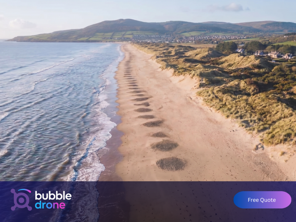
The collection of Irish coastal aerial photography available for print covers everything from the rugged north-west to the more sculpted bays of the south. Some of the most striking pieces are not the famous or scenic shots. They are the abstract ones: a wave breaking across a dark reef, a tidal flat at low water, a beach at dawn before anyone has walked it. These images work because they are not identifiably of anywhere in particular. They are about light and texture. The geometry of where the land meets the sea.
For a residential space, a coastal aerial print in a large format is one of the few photograph choices that holds the eye the way a painting does. It rewards looking. The detail in a high-resolution aerial beach photograph, the ripple in the sand, the colour shift in the shallow water, the perfect curve of a breaking wave, gives the viewer something to find each time they look at it, rather than a single image that reads completely in a glance.
Getting the Most From an Aerial Beach Shoot in Ireland
The difference between a good aerial beach shoot and a great one rarely comes down to the location. It comes down to the decisions made before the drone leaves the ground.
Give your pilot flexibility on timing. A shoot booked for 10am on a fixed date may land in flat grey overcast with a 30-knot wind. The same location at 7am on the following day, during a weather window your pilot has been tracking, produces a completely different result. The photographers whose coastal work you admire online all have something in common: they waited for the right conditions.
The brief matters as much as the location. Beach photography for a hotel website needs to show accessible, welcoming space. Beach photography for a surf school campaign needs energy and action. Beach photography for a residential property development needs context and scale. A skilled pilot composes and sequences the shoot differently depending on what the images need to do, but only if they know the purpose before they arrive.
Ask for a variety of altitudes and angles. Aerial beach photography is strongest when it includes a range: the sweeping wide-angle view from maximum altitude that gives you the whole bay, the mid-altitude shot that balances scale with detail, and the low near-surface shot that puts the viewer inside the landscape rather than above it. Together, they give you content that works at every scale, from a billboard to an Instagram frame, without a second shoot.
Frequently Asked Questions
Do you need a licence to fly a drone on a beach in Ireland?
For commercial aerial photography, yes. Pilots must hold the appropriate Irish Aviation Authority (IAA) authorisation under EASA regulations. Operating commercially without a licence is illegal. Always ask your pilot for proof of current IAA and EASA authorisation before booking. A fully licensed pilot will provide it without hesitation.
How long does an aerial beach shoot take in Ireland?
Most single-location beach shoots run between 90 minutes and four hours on site, depending on scope and conditions. A focused hospitality shoot in the right light window can be completed in 90 minutes. Multi-location coastal projects may run across two or three separate visits to capture different beaches and conditions. Edited deliverables are typically ready within two to five working days.
How much does aerial beach photography cost in Ireland?
Pricing depends on scope, location, and usage requirements. Residential packages are available at fixed rates. Commercial and promotional projects are quoted per brief. The more useful comparison is value: properties with professional photography earn on average 40% more revenue, and a single coastal shoot for a hospitality business typically pays for itself within the first day of additional bookings it generates. [Get a free quote] to scope your project.
Why Aerial Photography Has Changed How Ireland Sees Its Own Coastline
There is a practical reason to commission aerial beach photography, and there is a more interesting reason it has grown so quickly as a medium in Ireland.
Better images drive better commercial outcomes. A coastal hospitality business with strong aerial content books differently to one without it.
The more interesting reason is that aerial beach photography has given Ireland a view of its own landscape that it did not have before. Most Irish people have grown up with ground-level familiarity with the coast. They know particular beaches the way they know a room in their house: from inside, at eye level, from a fixed perspective.
An aerial photograph of a familiar beach is often genuinely surprising. The shape you did not know was there. The colour you assumed was only visible from a plane. The sheer scale of a cliff face or a dune system that ground level compresses into something manageable.
That surprise is what gives a great aerial beach photograph its staying power. It is the feeling of seeing somewhere you know as if for the first time.
Most clients say the same thing when they see their first aerial edit: they did not expect it to look like that. If you want to find out what your location looks like from the air, get a free quote and we will scope the shoot around your project.
Bubble Drone Services provides fully licensed commercial drone photography and videography across Ireland. IAA and EASA authorised, CoverDrone insured, and available for coastal, residential, and commercial projects nationwide. Get a quote for your aerial beach shoot.